


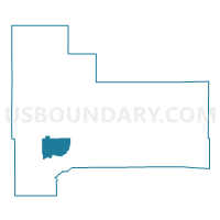
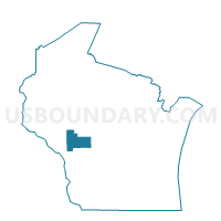
IRVING - T 2 Voting District, Jackson County, Wisconsin
About
Outline

Summary
| Unique Area Identifier | 694136 |
| Name | IRVING - T 2 Voting District |
| County | Jackson County |
| State | Wisconsin |
| Area (square miles) | 20.64 |
| Land Area (square miles) | 20.64 |
| Water Area (square miles) | 0.00 |
| % of Land Area | 100.00 |
| % of Water Area | 0.00 |
| Latitude of the Internal Point | 44.22256490 |
| Longtitude of the Internal Point | -90.97890760 |
Maps

Graphs
Select a template below for downloading or customizing gragh for IRVING - T 2 Voting District, Jackson County, Wisconsin


Neighbors
Neighoring Voting District (by Name) Neighboring Voting District on the Map
- ALBION - T 1 Voting District, Jackson County, WI
- FRANKLIN - T 1 Voting District, Jackson County, WI
- IRVING - T 1 Voting District, Jackson County, WI
Top 10 Neighboring County Subdivision (by Population) Neighboring County Subdivision on the Map
- Albion town, Jackson County, WI (1,210)
- Irving town, Jackson County, WI (751)
- Franklin town, Jackson County, WI (448)
Top 10 Neighboring Unified School District (by Population) Neighboring Unified School District on the Map
- Black River Falls School District, WI (12,306)
- Melrose-Mindoro School District, WI (4,393)
- Blair-Taylor School District, WI (4,272)